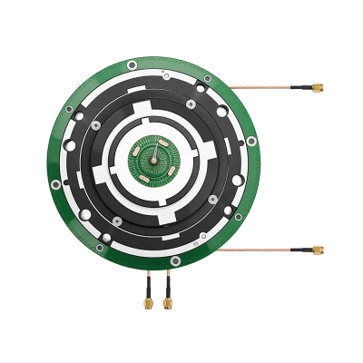
Gnss/Rtk Antenna/High-Precision Antenna
12 Years Of Accumulation In The Satellite Navigation Industry
National Service Hotline:
188-2651-7057
12 Years Of Accumulation In The Satellite Navigation Industry
188-2651-7057

2025-04-21
Can GNSS high-precision antennas really reduce positioning errors to millimeter level? In scenarios such as autonomous driving, drone mapping, and deformation monitoring, people's desire for the word "precision" is unprecedented. To answer this question, one must first understand the technical logic, engineering details, and commercial considerations behind the antenna.
1、Technical Basis - From Satellite Signals to Phase Calculation
The global navigation satellite system can simultaneously receive signals from multiple constellations such as GPS, Beidou, GLONASS, etc. High precision antennas are designed with multiple feed points and anti multipath structures to maintain phase center stability as much as possible; Combined with T-Choke or dielectric cover, weaken the reflection waves near the ground. The phase observation values are solved by RTK or PPP algorithms, and centimeter or even millimeter level coordinates are born from this.
2、 Design Points - Concerto of Form, Material, and Work
Form: There are three common categories: circularly polarized spiral, dielectric resonator, and microstrip array, each of which balances volume, bandwidth, and directional pattern.
Material: Low dielectric constant PTFE, ceramic glass fiber or LCP flexible substrate, used to reduce dielectric loss.
Process: Coaxial feeding, integral milling of metal cover, nitrogen reflow soldering, temperature and humidity control throughout the entire process to ensure consistency of solder joints and integrity of grounding.
3、Application Panorama - Cross industry Invisible Pivot Point
Precision agriculture: The tractor is equipped with a dual antenna RTK system, with a walking trajectory error of ≤ 2 cm, saving fertilizer and fuel.
Deformation monitoring: The slight deformation of the bridge under stress can capture a displacement of 1 mm in advance and provide timely warning.
Unmanned aerial vehicle oblique photography: Ensuring model overlap accuracy and improving field efficiency even with a sharp reduction in GCP.
Maritime surveying: Dynamic positioning ship array antenna, achieving surge compensation and precise anchoring.
Autonomous driving: integrated with IMU and V2X, supporting lane level and even distance level navigation on the inside of the lane.
4、 Sexual Energy Scale - How to detect "good or bad"
Phase center deviation (PCO/PCV): Three dimensional deviation of ≤± 2 mm is considered superior.
Group delay consistency: Within the same frequency band, it does not exceed 1 ns, which can significantly improve the robustness of multi constellation combination calculation.
Zenith gain: Normal environment ≥ 5 dBic, polar missions need to reach 7 dBic or above.
Suppression ratio: The industry commonly uses L1/L2 region average suppression>20 dB to resist urban canyon multipath.
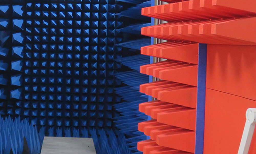
The verification process usually involves OTA testing in a darkroom, supplemented by field reference station observation.
5、Selection and Procurement - From Laboratory to Site
Task matching: Static monitoring prioritizes low phase drift; Sports carriers place greater emphasis on lightweight and compatibility with multiple constellations.
Interface form: External antenna commonly used TNC/N type; Embedded modules are MCX or solder pads.
Accessories: Signal amplifier, low-noise amplifier, and lightning arrester are indispensable, especially in high humidity and high salt spray waters.
Budget balance: If mass production exceeds the thousand level, ODM solutions can be considered to reduce unit prices through shared molds.
Ultimately, it is necessary to verify the factory inspection report, warranty terms, and after-sales response time.
6、Challenge and Prospect - The Next Stop of Precision
Satellite based enhanced popularization: L-band broadcasting is accelerating the "cloudification" of ground reference stations, and antennas must be compatible with more frequency points.
Interference and Deception: City Car Connect NetEase is affected by 5G and Wi Fi interference, and both anti-interference antennas and adaptive array algorithms are equally important.
Integration trend: The integration of antenna module antenna cover is becoming a new standard for vehicle specifications, with thickness conforming to the roofline.
◆ Low Earth Orbit Satellite Addition: When the navigation satellite descends from an altitude of 20000 km to 1000 km, the observation geometry changes, and the antenna beam shape and tracking strategy will be rewritten.
From exploring isolated islands to the interconnectivity of all things, every step in positioning accuracy expands the industrial landscape. GNSS high-precision antennas are like "millimeter eyes", allowing devices to truly see their own coordinates rather than blurry contours. If selected correctly and used steadily, it will silently measure the world in autonomous driving fleets, farmland, oceans, and urban skylines, laying an intangible benchmark for the next generation of spatial intelligence.


Tel:188-2651-7057(Mr. Yan) Phone:0755-23205219
Email:yqh@hx-iot.com
Company Address:2-5 Floors, West Of Building C10, Xin'an Second Industrial Zone, Gushu 2nd Road, Xixiang, Bao'an District, Shenzhen
Factory Address:No. 667 Huancheng South Road, Chengnan Industrial Park, Yuanzhou District, Yichun City, Jiangxi Province
Official Website:www.hxrf-antenna.com


 Follow Us
 188-2651-7057
 Online Service
 Enterprise Email